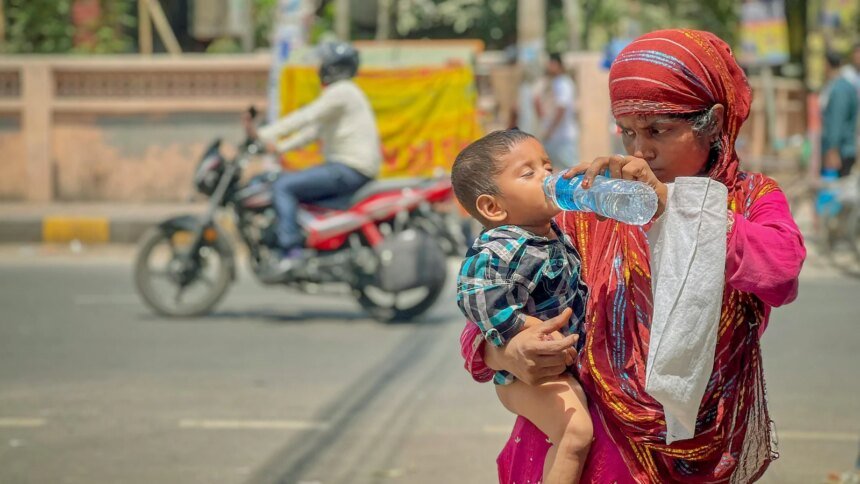
Large parts of India remained in the grip of heat wave on Tuesday with temperatures in major cities rising well above seasonal norms. The temperature in Delhi was recorded at 42 to 44 degrees Celsius, while the mercury reached 41 to 43 degrees in Ahmedabad and Nagpur and 40-41 degrees in Jaipur and Lucknow.
The temperature in Banda, Uttar Pradesh, crossed 47 degrees – a dreadful 47.6 – for the second consecutive day, with similarly brutal conditions in Maharashtra’s Vidarbha in the south.
Advertisement – Scroll to continue
Daytime peaks in Hyderabad and Chennai were seen in the mid 30s. Coastal Mumbai remained relatively cool – in the high 30s – but humid, and Kolkata reported temperatures in the high 30s.
Locals expecting cool nights were disappointed as the minimum temperature was five degrees above normal at many places including Delhi and Jammu and Kashmir.
weather forecast
The week’s forecast offers little immediate relief for large parts of the Northwest and central states. The India Meteorological Department fears that severe heat wave conditions will persist for several days and the temperature is likely to be several degrees higher than normal.
In fact, it may continue to cross 45 degrees in isolated areas before western disturbances and localized thunderstorms move into parts of the north and north-east.
In the south, hot daytime conditions can be expected with muggy and uncomfortable nights in major cities, while parts of the north-east and east will see more rain and thunderstorms.
Why is India burning?
To some extent this is a regular seasonal phenomenon; The months of April and May usually experience high heat due to increased solar radiation, dry continental winds and the formation of low pressure thermal areas over western states such as Rajasthan and neighboring Pakistan.
But the intensity and spread of this heatwave – which has painted the subcontinent fiery shades of orange and dark brown – is the result of both domestic and global factors.
Domestic reasons behind heat wave in India
At the domestic level this includes the ‘urban heat island’ effect, which refers to a phenomenon in which cities and metropolitan areas see much warmer temperatures – sometimes as much as 10 °C higher – than surrounding rural areas. The main reason for this is that vegetation and green cover in cities has been replaced by steel, glass and concrete structures which absorb heat.

Other factors include below-normal pre-monsoon rainfall, clear skies and stalled circulation patterns, all of which prevent cold air from the oceans from reaching inland areas.
Experts say climate change – driven by anthropogenic greenhouse gas emissions, that is, heat-trapping gases released by human activities – is also at play, acting as a background stress multiplier to force higher baseline temperatures during the summer that then trigger heatwaves.
El Nino factor
There are two factors at the global level, one of which is El Niño conditions developing in the equatorial Pacific. Data modeling from the World Meteorological Organization indicates a high probability – 62 to 80+ percent – that it will establish itself between May and August.
El Nino (and its counterpart, La Nina) are Spanish words – which translate as ‘little boy’ and ‘little girl’ – which are originally climate patterns in the Pacific Ocean that determine weather around the world.
Essentially the ‘little boy’ brings a period of unusually warm weather and the ‘little girl’ is the opposite, and occurs when surface temperatures over the Pacific Ocean are either too hot or too cold.
It is not that El Nino or La Nina occurs every year or that its effect is the same everywhere in the world. In fact, regional effects can vary considerably. But the general trend in the El Niño cycle is continued warmth; 2024, the hottest year on record, was driven by this same factor.
The IMD noted the possible development of El Nino conditions this year as well.
impact on india
An important impact – certainly for India – is on monsoon rainfall.
In the El Niño phase, warm Pacific Ocean water is pushed south and east, meaning that areas to the east, i.e. Asia, Australia and Central Africa, typically experience dry weather.

Heat waves and drought are not uncommon in India but the intensity has increased.
The IMD has already issued a statement warning that the 2026 southwest monsoon is “likely to be below normal (90-95 per cent) of the long period average (LPA)” and “seasonal rainfall over the entire country is likely to be 92 per cent of LPA (five per cent variation)”.
how to stay safe
The practical implications of the heatwave are immediate.
Hospitals must prepare for heat-related illnesses and power grids face high energy consumption and cooling demands. Farmers in rural areas will have to deal with heat stress on crops and livestock.
Health advice issued by the government and doctors includes the need for hydration, limiting outdoor exposure during peak hours and paying attention to heatstroke symptoms.
As India moves through this window, the focus will be on the strength of western disturbances and the arrival pattern of the southwest monsoon as well as any local activity that could produce significant and prolonged rainfall, i.e. thunderstorms.
Until then, residents of the most affected plains should plan for continued high temperatures and take preventive measures to minimize health and economic losses.